back to Introduction to Edwards Plateau Vegetation and Ecology
Geology Soils Climate Seasons and phenology
Geology rules - or at least it's pretty important
The Edwards Plateau is a very large, roughly oblong region in central Texas defined by its bedrock: very thick, mostly flat layers of rock composed primarily of hard early Cretaceous limestone. Its eastern and southeastern boundaries are defined by an old fault zone (now inactive), the Balcones Escarpment. The rocks, soils, and plants east of the Edwards Plateau are quite different from those of the Plateau.
Go to http://www.tpwd.state.tx.us/landwater/land/maps/gis/map_downloads/ and choose any of the maps labeled ‘natural regions’ to see the location of the Edwards Plateau.
In north-central Austin, MoPac (Loop 1) runs along the edge of the Plateau; the land to the west of MoPac is on the Plateau. Loop 360 has some large road cuts through the Cretaceous limestone of the Plateau. In a few of these road cuts you can see some folding of the rock layers due to the faulting that occurred there. San Antonio and San Marcos also lie on the eastern edge of the Edwards Plateau.
The Plateau extends west to the Pecos River, about 250 miles (or about 400 km) west of Austin. Its northern and southwestern boundaries are not sharply defined. The Plateau is about 100 miles (or about 150 km) north to south.
Northwest of Austin is a region of exposed granite centered in Llano (pronounced lannoe, as in lanolin) and Mason counties. Around the granite are uplifted Paleozoic rocks. Properly speaking, the Llano Uplift is not part of the Edwards Plateau.
The eastern Edwards Plateau is often called the Hill Country, a reference to its many steep hillsides and valleys. This topography has been created by erosion: the flat layers of rock have been cut through by the many streams and rivers in the region. The Glen Rose formation tends to have limestone layers that are alternatively hard and soft, creating a characteristic ‘stair-stepped’ appearance.
As a result of the presence of thick layers of limestone, the region has creeks that lose water down into the ground, caves, and springs. The Edwards Aquifer underlies the eastern Edwards Plateau. Its recharge zone (the zone where water travels from the surface of the ground down into the aquifer) lies along the eastern edge of the aquifer. Its watershed is much larger. The segment of the Edwards Aquifer that provides the water that comes to the surface at Barton Springs (in Zilker Park, which is in downtown Austin just south of Town Lake) receives water from Barton Creek and Onion Creek, so its watershed includes much of southwestern Travis County and northwestern Hays County. A good site for more information about the Edwards Aquifer is http://www.edwardsaquifer.net/.
There are no natural lakes in central Texas, mostly because it was not glaciated. The Colorado River has been dammed to produce a series of reservoirs: Town Lake (created by Longhorn Dam in east Austin), then Lake Austin (created by the Tom Miller Dam near Brackenridge Field Laboratory), Lake Travis (created by Mansfield Dam), and so on. Lake Travis and Lake Buchanan are flood control lakes; their levels rise and fall as the water in them is stored and released. The LCRA (Lower Colorado River Authority, http://www.lcra.org/index.html) administers these dams and reservoirs and some parks located on their shores. Before the dams were built Austin and other river towns flooded frequently.
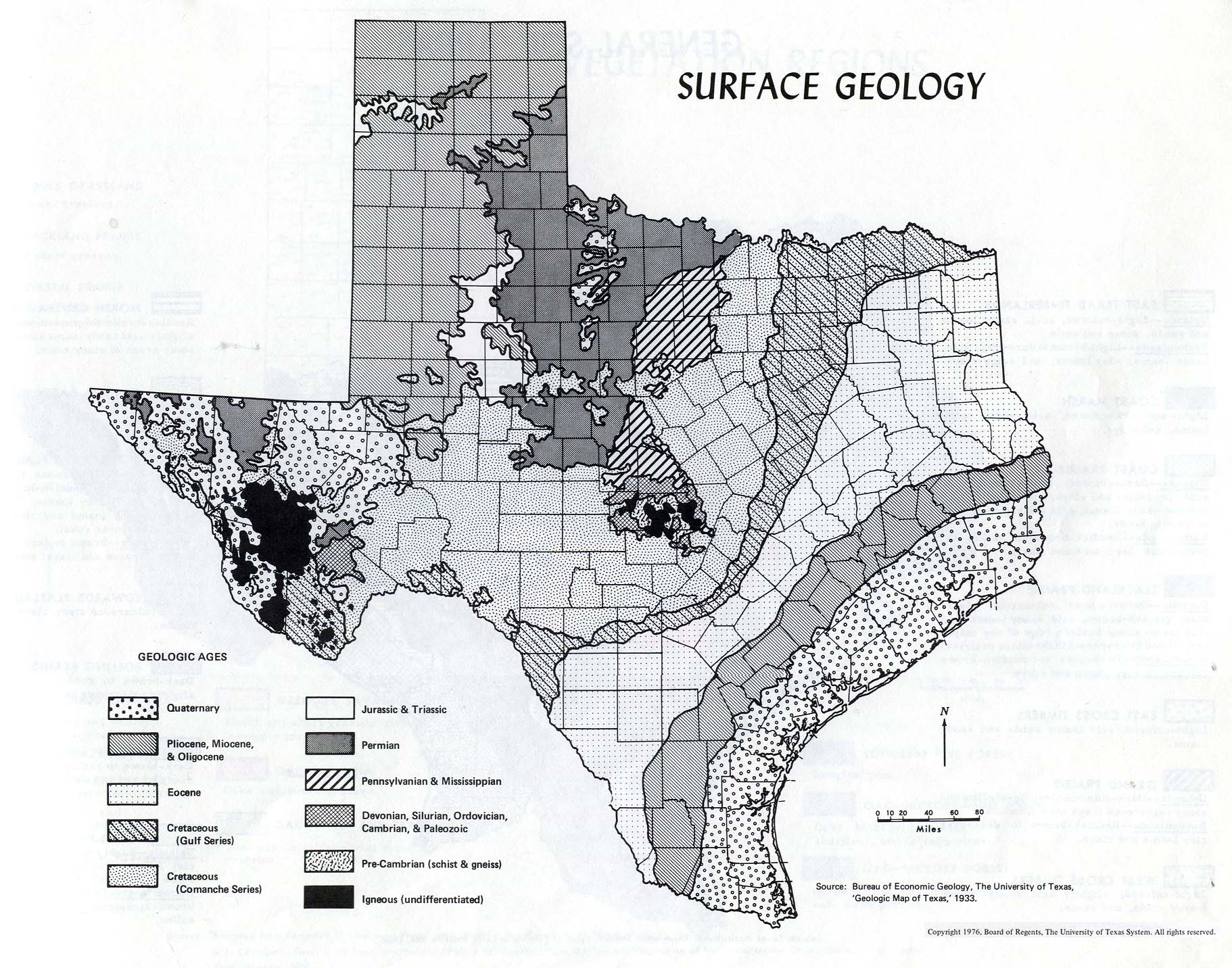
For more information about the geology of the Austin area, see http://www.lib.utexas.edu/geo/ggtc/toc.html. A useful book that covers all of Texas is Roadside Geology of Texas, by Darwin Spearing. For a simplified geological map of Texas, see http://www.lib.utexas.edu/maps/atlas_texas/surface_geology_tx.jpg.
Topography and geology, and maybe land use history, determine the soils
Soil maps are available for each county from the Natural Resources Conservation Service (NRCS), a federal agency (http://www.tx.nrcs.usda.gov/). Inspection of these maps reveals that topography (slope or flat, ridge or valley) tends to be closely related to soil type. Soils are often very shallow, and exposed bedrock is common. The Plateau may have had deeper soils before settlement than it does now. In many places no A horizon is now evident.
Soils in this region tend to have relatively high clay contents, due to their origin from limestone. If the soil is more than a few inches thick, it is likely to have a caliche layer. (Caliche is redeposited calcium carbonate, i.e., the same chemical substance as limestone). In practice it is often hard to distinguish caliche from marl, a softer limestone with some clay in it, in the field; both are crumbly white substances.
Soils tend to be neutral to alkaline with a high calcium carbonate content. Alkaline soils tend to make iron unavailable to plants. Plants adapted to sandy soils therefore tend to develop iron deficiency in Austin, easily seen as green veins on yellow leaves on the magnolia trees on campus, and as green-and-yellow longitudinal stripes in the leaves of St. Augustine grass in Austin lawns. This, in addition to the lower rainfall, may be why few east Texas plant species grow on the Plateau.
The climate is challenging
Californians think Austin is humid, Houstonians think it’s pleasantly dry, but everyone agrees that it is hot. Not surprisingly, perhaps, as Austin is at the same latitude as Cairo, Egypt.
The climate tends to be 'continental' rather than 'oceanic', despite the presence of the Gulf of Mexico about 200 miles (125 km) away: temperature changes are often large and rapid, especially when a 'norther' arrives. The climate falls on the boundary between subhumid and semi-arid.
Austin’s average daily high temperature in August is about 97o F (36o C) and the average low temperature in January is 40o F (4o C). Every couple of years there is a freeze in Austin, which prevents truly tropical species from living here. Freezes are more common further west on the Edwards Plateau. The ground does not freeze, and snow is rare and ephemeral. Winter temperatures fluctuate widely. Winter cold spells are usually due to the arrival of a ‘norther’ coming down the Great Plains, when temperatures really can drop 50o F (28o C) in a day.
Austin receives about 34 inches (860 mm) of rainfall per year, which seems like a lot to those from cooler regions, but is only about half of the potential evapo-transpiration (i.e., the amount that would evaporate from a continuously wet surface in a year). For monthly rainfall and temperatures in Austin, see http://www.srh.noaa.gov/ewx/html/cli/ausnorm.htm.
There is a strong gradient of rainfall from east to west across Texas. For example, Fredricksburg, 120 miles (75 km) west of Austin, receives an average of only 27.5 inches (700 mm) per year.
In most of the drier parts of the world, precipitation is seasonal and therefore somewhat predictable. There is NO predictably wet month in this region, and NO day in which the plants may not have to survive one or even two subsequent months without rain. Only in May is the mean rainfall greater than one standard deviation of the rainfall. Rainfall also varies greatly from year to year. The hot temperatures, unpredictable rainfall, and thin soils make the eastern Edwards Plateau ecosystems much more subject to water limitation than the rainfall alone might make you expect.
The shallow soils, steep topography, and often intense rainfall make the area one of the most flood-prone in the world. DO NOT DRIVE INTO LOW WATER CROSSINGS IF THEY HAVE WATER IN THEM. BE CAUTIOUS ALONG CREEKS even if the sky is blue and cloudless; there could have been rain upstream. Every year there are flood-related deaths.
Plant in October (or January), harvest in June, bake in August
Spring begins in central Texas at the beginning of February, when the first buds open on the trees, although most people don't notice it then.
The roadside wildflowers are usually at their best in late March.
Really hot weather usually begins some time in May. May is the month with the greatest average rainfall, although there have been rainless Mays.
You can ‘watch’ the soil dry out during the summer by watching the native grass species die back. As the soil dries out, these plants turn brown from their leaf tips towards the base of the tiller. At the same time the depth at which detectable soil moisture is no longer present is increasing. The appearance of the vegetation in the city is deceptive; almost all of it is irrigated.
Rainfall in late August and in September is often due to a hurricane in the western Gulf of Mexico, so it is especially variable.
It WILL cool down, but probably not until October.
Except in the driest years, there will come a time when there is significant rainfall AND the temperatures are cool enough for the soil to remain moist. That is when almost all native plants germinate. (If they waited for the spring, their roots would not be deep enough to survive the summer.) Plant seeds then.
Transplants are MUCH more likely to survive if transplanted sometime between then and February. March is often too late. December or January are best, unless you are prepared to irrigate.
back to Introduction to Edwards Plateau Vegetation and Ecology